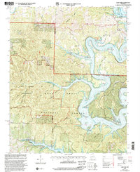
1999 Map of Cape Fair
USGS Topo · Published 2002About this map
Table Rock Lake dominates this portion of the Ozark Plateau, its sinuous fingers reaching deep into the drainage basins of the James River and Flat Creek. The settlement of Cape Fair is perched near the confluence of these major waterways, supported by local institutions like the Cape Fair Ch and Cape Fair Cem. The map reveals a landscape defined by sharp topographic relief, where numerous hollows such as Gravelly Hollow and Mash Hollow descend toward the flooded river valleys. To the west, the land transitions into the protected terrain of the Mark Twain National Forest, with the Piney Creek Wilderness Boundary marking a shift toward more primitive backcountry. Traces of local utility and community life appear at the Woolly Creek Community Hall and several boat access points, while Virgin Bluff stands as a prominent landmark over the winding river below.
Find a feature on this map
36 named features on this map. Tap any name to fly to it.
Don’t see what you’re looking for? This feature index may not catch every label — zoom into the map to look around manually.
Map Details
Editions of this 1999 Cape Fair Map
This is the sole edition of this map. No revisions or reprints were ever made.
Other maps of this area

1907 · Forsyth
USGS Topo · 1:125,000

1927 · Shell Knob
USGS Topo · 1:62,500

1942 · Aurora
USGS Topo · 1:62,500

1945 · Harrison
USGS Topo · 1:250,000

1945 · Aurora
USGS Topo · 1:62,500

1949 · Harrison
USGS Topo · 1:250,000

1950 · Shell Knob
USGS Topo · 1:62,500

1954 · Harrison
USGS Topo · 1:250,000

1956 · Lampe
USGS Topo · 1:24,000
1956 · Reeds Spring
USGS Topo · 1:24,000