
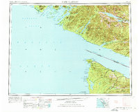
1953 Map of Cape Flattery
USGS Topo · Published 1968About this map
The Strait of Juan de Fuca serves as the international maritime corridor between the Olympic Peninsula and Vancouver Island in this 1953 survey, updated for the American side in 1968. On the Washington coast, the Makah Indian Res anchors the northernmost tip at Cape Flattery, where the Neah Bay Force Station overlooks the entrance to the inland waters. The landscape transition is stark, from the coastal reaches of the Olympic National Park and the isolated Ozette Lake to the timber-dense slopes of the Pelham Range and San Juan Ridge across the water. On the Canadian side, the settlement of Port Renfrew and the logging hub at Lake Cowichan highlight the resource-driven development of the Vancouver Island Provincial Forest. Local connectivity is defined by remote outposts like Ucluelet and Bamfield along the complex inlets of Barkley Sound.
Find a feature on this map
90 named features on this map. Tap any name to fly to it.
Don’t see what you’re looking for? This feature index may not catch every label — zoom into the map to look around manually.
Map Details
Editions of this 1953 Cape Flattery Map
2 editions found
Other maps of this area

1918 · Lake Crescent
USGS Topo · 1:62,500

1922 · Pysht
USGS Topo · 1:62,500

1922 · Lake Crescent
USGS Topo · 1:62,500

1935 · Clallam
USGS Topo · 1:62,500

1935 · Ozette Lake
USGS Topo · 1:62,500

1935 · Lake Pleasant
USGS Topo · 1:62,500

1938 · Cape Flattery
USGS Topo · 1:62,500

1939 · Forks
USGS Topo · 1:62,500

1939 · Mount Tom
USGS Topo · 1:62,500

1942 · Pysht
USGS Topo · 1:62,500