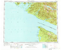
1953 Map of Cape Flattery
USGS Topo · Published 1976About this map
The Strait of Juan de Fuca divides this maritime region, marking the international boundary between British Columbia and Washington. On the northern shore, Vancouver Island settlements like Ucluelet and Port Renfrew sit amidst the Vancouver Island Provincial Forest. To the south, the northwestern tip of the United States is dominated by the Makah Indian Res and the prominent Cape Flattery. The map captures the remote timber and coastal economy of the mid-20th century, showing early road networks connecting Sekiu and Clallam Bay. An Old Railroad Grade winds through the interior near Beaver, evidencing the area's logging history. Coastal landmarks such as Tatoosh I and the Flattery National Wildlife Refuge highlight the transition from the protected waters of Barkley Sound to the open Pacific Ocean.
Find a feature on this map
63 named features on this map. Tap any name to fly to it.
Don’t see what you’re looking for? This feature index may not catch every label — zoom into the map to look around manually.
Map Details
Editions of this 1953 Cape Flattery Map
2 editions found

Other maps of this area

1918 · Lake Crescent
USGS Topo · 1:62,500

1922 · Pysht
USGS Topo · 1:62,500

1922 · Lake Crescent
USGS Topo · 1:62,500

1935 · Clallam
USGS Topo · 1:62,500

1935 · Ozette Lake
USGS Topo · 1:62,500

1935 · Lake Pleasant
USGS Topo · 1:62,500

1938 · Cape Flattery
USGS Topo · 1:62,500

1939 · Forks
USGS Topo · 1:62,500

1939 · Mount Tom
USGS Topo · 1:62,500

1942 · Pysht
USGS Topo · 1:62,500