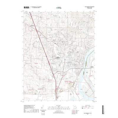
2017 Map of Cape Girardeau
USGS Topo · Published 2017About this map
The Mississippi River defines the eastern edge of this Missouri landscape, where the urban center of Cape Girardeau meets the fertile lowlands of Black Land Bottom. The geography is characterized by the river’s dramatic Big Bend and several riverine features like Giboney Island and Marquette Island. Inland, the terrain shifts from the developed corridors of Jackson and Scott City to the high ground of Mt Tabor and the creek valleys of Cape La Croix Cr. Local institutional history is anchored by Southeast Missouri State University and several healthcare campuses. Numerous family and community burial grounds, including Old Lorimier Cem, McKendree Cem, and Minton Cem, are distributed across the township grids of t31n r13e and t30n r14e, offering a detailed map of the region’s ancestral settlements.
Find a feature on this map
58 named features on this map. Tap any name to fly to it.
Don’t see what you’re looking for? This feature index may not catch every label — zoom into the map to look around manually.
Map Details
Editions of this 2017 Cape Girardeau Map
This is the sole edition of this map. No revisions or reprints were ever made.
Other maps of this area

1920 · Jonesboro
USGS Topo · 1:62,500

1922 · Cape Girardeau
USGS Topo · 1:62,500

1923 · Jonesboro
USGS Topo · 1:62,500

1924 · Cape Girardeau
USGS Topo · 1:62,500

1934 · Thebes
USGS Topo · 1:62,500

1934 · Morley
USGS Topo · 1:62,500

1939 · Morley
USGS Topo · 1:62,500

1939 · Thebes
USGS Topo · 1:62,500

1947 · Jonesboro
USGS Topo · 1:62,500

1947 · Mc Clure
USGS Topo · 1:24,000