
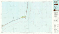
1985 Map of Cape Hatteras
USGS Topo · Published 1985About this map
Cape Hatteras National Seashore dominates this mid-1980s coastal survey, depicting the fragile barrier islands where the Atlantic Ocean meets Pamlico Sound. This planimetric study illustrates the precarious geography of the Outer Banks, from the curved hook of Cape Hatteras to the narrow stretch of Ocracoke Island. The map records a specific moment in maritime history, noting the Cape Hatteras Lighthouse (Aband) and the Cape Hatteras Coast Guard Sta at the elbow of the coast.
Find a feature on this map
34 named features on this map. Tap any name to fly to it.
Don’t see what you’re looking for? This feature index may not catch every label — zoom into the map to look around manually.
Map Details
Editions of this 1985 Cape Hatteras Map
2 editions found
Other maps of this area

1943 · Columbia
USGS Topo · 1:125,000

1943 · Roanoke Island
USGS Topo · 1:125,000

1948 · Cape Hatteras
USGS Topo · 1:24,000

1948 · Buxton
USGS Topo · 1:24,000

1948 · Portsmouth
USGS Topo · 1:24,000
1948 · Ocracoke
USGS Topo · 1:24,000

1950 · Cape Hatteras
USGS Topo · 1:24,000

1950 · Howard Reef
USGS Topo · 1:24,000

1950 · Buxton
USGS Topo · 1:24,000

1950 · Portsmouth
USGS Topo · 1:24,000