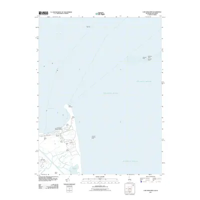
2011 Map of Cape Henlopen
USGS Topo · Published 2011About this map
Cape Henlopen defines the convergence of the Delaware Bay and the Atlantic Ocean in this 2011 survey of the Delaware coast. The landscape is a complex of shifting maritime environments, from the submerged hazards of Overfalls Shoal and Hen and Chickens Shoal to the terrestrial reaches of Sand Hill and Wolfe Neck. The map provides a precise look at the specialized infrastructure of the point, including the University of Delaware College of Marine Studies and the transit path of the Lewes-Cape May Ferry. Inland, residential and industrial growth is visible around Gills Neck and Barcroft Airport. A series of numbered observation points, such as Tower Number Seven and Tower Number Eight, are positioned along the coast, likely serving as remnants or active components of maritime surveillance and coastal defense infrastructure.
Find a feature on this map
27 named features on this map. Tap any name to fly to it.
Don’t see what you’re looking for? This feature index may not catch every label — zoom into the map to look around manually.
Map Details
Editions of this 2011 Cape Henlopen Map
This is the sole edition of this map. No revisions or reprints were ever made.
Other maps of this area

1888 · Cape May
USGS Topo · 1:62,500

1893 · Cape May
USGS Topo · 1:62,500

1898 · Cape May
USGS Topo · 1:62,500

1918 · Rehoboth
USGS Topo · 1:62,500

1918 · Cape Henlopen
USGS Topo · 1:62,500

1918 · Cape May
USGS Topo · 1:62,500

1925 · Cape May
USGS Topo · 1:62,500

1937 · Cape Henlopen
USGS Topo · 1:62,500

1938 · Rehoboth
USGS Topo · 1:62,500
1940 · Cape May
USGS Topo · 1:62,500