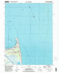
1997 Map of Cape Henlopen
USGS Topo · Published 2000About this map
Cape Henlopen forms a sharp geological divide where the Delaware Bay meets the Atlantic Ocean, creating a complex maritime environment dominated by shifting sands and protective harbors. This late 20th-century survey details the navigational infrastructure required for this busy coastal junction, including multiple Lights, a Lighthouse, and several Lookout Towers positioned to manage traffic entering Breakwater Harbor. The landscape is a mix of conservation and research, anchored by Cape Henlopen State Park and the Univ of Del Col of Marine Studies. Inland, the terrain softens into the Sand Hill and Flat Sands areas, while coastal wetlands like Gordons Pond and the tidal reaches of Wolfe Glade define the southern marshes. Local communities such as Lewes, Gills Neck, and Wolfe Neck are shown at a time of steady coastal footprint, positioned just behind the protective barrier of the dunes.
Find a feature on this map
31 named features on this map. Tap any name to fly to it.
Don’t see what you’re looking for? This feature index may not catch every label — zoom into the map to look around manually.
Map Details
Editions of this 1997 Cape Henlopen Map
This is the sole edition of this map. No revisions or reprints were ever made.
Other maps of this area

1888 · Cape May
USGS Topo · 1:62,500

1893 · Cape May
USGS Topo · 1:62,500

1898 · Cape May
USGS Topo · 1:62,500

1918 · Rehoboth
USGS Topo · 1:62,500

1918 · Cape Henlopen
USGS Topo · 1:62,500

1918 · Cape May
USGS Topo · 1:62,500

1925 · Cape May
USGS Topo · 1:62,500

1937 · Cape Henlopen
USGS Topo · 1:62,500

1938 · Rehoboth
USGS Topo · 1:62,500
1940 · Cape May
USGS Topo · 1:62,500