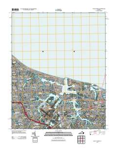
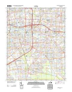
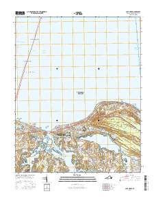
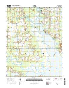
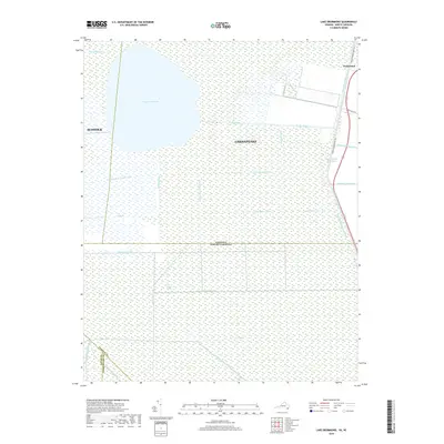
1919 Map of Cape Henry
USGS Topo · Published 1932About this map
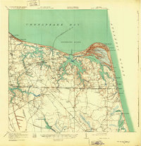
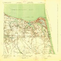
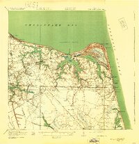
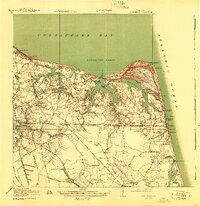
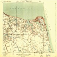
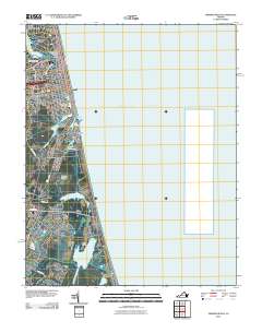
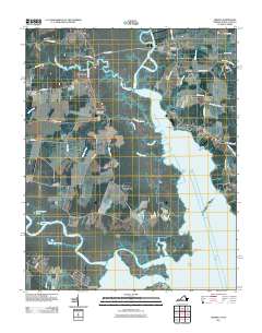
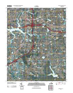
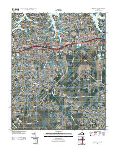
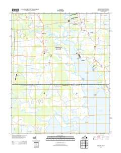
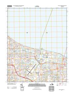
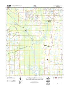
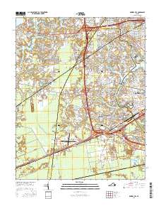
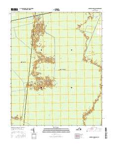
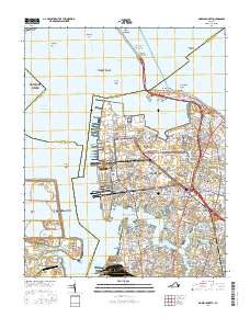
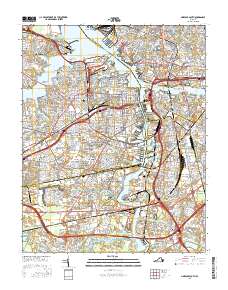
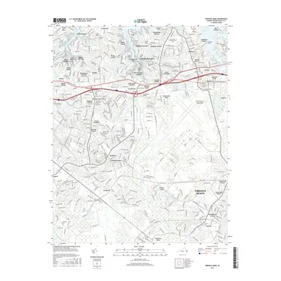
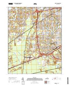
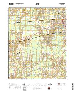
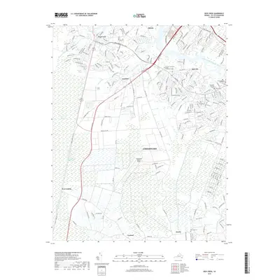
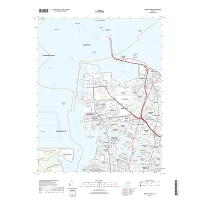
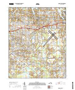
Old Donation Church stands as a spiritual landmark near the complex waterways of Lynnhaven Bay and the Western Branch, anchoring a landscape defined by the convergence of the Chesapeake Bay and the Atlantic Ocean. This 1918 survey documents the coastal character of Virginia before mid-century modernization, showing the sprawling woodlands of The Desert and the shifting sands near Cape Henry. The map captures an era of rail-dependent transit, with the Southern and Norfolk lines intersecting at Kempsville and spurs reaching out to Ocean View. Local infrastructure is visible through the Norfolk County Waterworks and Norfolk City Home, while small family-named crossroads like Bonneys Corner and Smiths Corner suggest the rural genealogy of the area. Educational and religious life is preserved through labels like the W E Biddle School and Eastern Shore Chapel, providing a clear view of the settlement patterns that preceded the region's suburban expansion.
Find a feature on this map
103 named features on this map. Tap any name to fly to it.
Don’t see what you’re looking for? This feature index may not catch every label — zoom into the map to look around manually.
Map Details
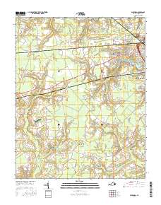
Editions of this 1919 Cape Henry Map
7 editions found

Historical Maps of Broad Creek Through Time
165 maps found

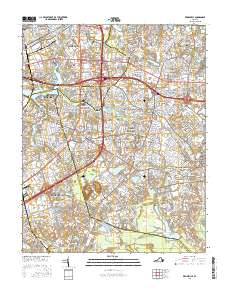
1907 Norfolk
Virginia

1916 Back Bay
Virginia

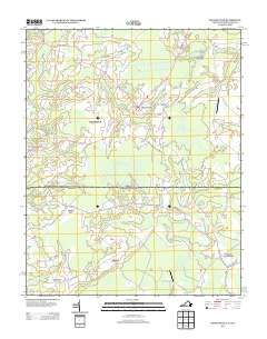
1918 Cape Henry
Virginia

1919 Cape Henry
Virginia

1919 Suffolk
Virginia

1931 Rural Retreat
Virginia

1935 Charlottesville And Vicinity
Virginia

1940 Lake Drummond
Virginia

1943 Back Bay
Virginia

1944 Hampton
Virginia

1944 Norfolk South
Virginia

1945 Lake Drummond
Virginia

1948 Kempsville
Virginia

1948 Norfolk North
Virginia

1948 Norfolk South
Virginia

1948 Ocean View
Virginia

1948 Princess Anne
Virginia

1948 Virginia Beach
Virginia

1952 Bowers Hill
Virginia

1952 Cape Henry
Virginia

1953 North Bay
Virginia

1954 Buckhorn
Virginia

1954 Corapeake
Virginia

1954 Creeds
Virginia

1954 Deep Creek
Virginia

1954 Fentress
Virginia

1954 Knotts Island
Virginia

1954 Lake Drummond
Virginia

1954 Lake Drummond NW
Virginia

1954 Lake Drummond SE
Virginia

1954 Ocean View
Virginia

1954 Pleasant Ridge
Virginia

1954 Suffolk
Virginia

1954 Suffolk
Virginia

1955 Bowers Hill
Virginia

1955 Cape Henry
Virginia

1955 Hampton
Virginia

1955 Kempsville
Virginia

1955 Norfolk North
Virginia

1955 Norfolk South
Virginia

1955 Princess Anne
Virginia

1955 Virginia Beach
Virginia

1960 Charlottesville And Vicinity
Virginia

1964 Cape Henry
Virginia

1964 Little Creek
Virginia

1965 Bowers Hill
Virginia

1965 Hampton
Virginia

1965 Kempsville
Virginia

1965 Norfolk North
Virginia

1965 Norfolk South
Virginia

1965 Princess Anne
Virginia

1965 Virginia Beach
Virginia

1967 Whaleyville
Virginia

1973 Hampton
Virginia

1977 Corapeake
Virginia

1977 Creeds
Virginia

1977 Deep Creek
Virginia

1977 Lake Drummond
Virginia

1977 Lake Drummond NW
Virginia

1977 Lake Drummond SE
Virginia

1977 Suffolk
Virginia

1994 Bowers Hill
Virginia

1994 Kempsville
Virginia

1994 Norfolk South
Virginia

1997 Suffolk
Virginia
2010 Cape Henry
Virginia
2010 North Bay
Virginia
2010 Suffolk
Virginia
2010 Virginia Beach
Virginia
2010 Whaleyville
Virginia
2011 Bowers Hill
Virginia
2011 Buckhorn
Virginia
2011 Creeds
Virginia
2011 Deep Creek
Virginia
2011 Fentress
Virginia
2011 Hampton
Virginia
2011 Kempsville
Virginia
2011 Lake Drummond
Virginia
2011 Lake Drummond NW
Virginia
2011 Lake Drummond SE
Virginia
2011 Little Creek
Virginia
2011 Norfolk North
Virginia
2011 Norfolk South
Virginia
2011 Pleasant Ridge
Virginia
2011 Princess Anne
Virginia
2013 Bowers Hill
Virginia
2013 Buckhorn
Virginia
2013 Cape Henry
Virginia
2013 Creeds
Virginia
2013 Deep Creek
Virginia
2013 Fentress
Virginia
2013 Hampton
Virginia
2013 Kempsville
Virginia
2013 Lake Drummond
Virginia
2013 Lake Drummond NW
Virginia
2013 Lake Drummond SE
Virginia
2013 Little Creek
Virginia
2013 Norfolk North
Virginia
2013 Norfolk South
Virginia
2013 North Bay
Virginia
2013 Pleasant Ridge
Virginia
2013 Princess Anne
Virginia
2013 Suffolk
Virginia
2013 Virginia Beach
Virginia
2013 Whaleyville
Virginia
2016 Bowers Hill
Virginia
2016 Buckhorn
Virginia
2016 Cape Henry
Virginia
2016 Creeds
Virginia
2016 Deep Creek
Virginia
2016 Fentress
Virginia
2016 Hampton
Virginia
2016 Kempsville
Virginia

2016 Lake Drummond
Virginia
2016 Lake Drummond NW
Virginia
2016 Lake Drummond SE
Virginia
2016 Little Creek
Virginia
2016 Norfolk North
Virginia
2016 Norfolk South
Virginia
2016 North Bay
Virginia
2016 Pleasant Ridge
Virginia
2016 Princess Anne
Virginia
2016 Suffolk
Virginia
2016 Virginia Beach
Virginia
2016 Whaleyville
Virginia
2019 Bowers Hill
Virginia
2019 Buckhorn
Virginia
2019 Cape Henry
Virginia
2019 Creeds
Virginia
2019 Deep Creek
Virginia
2019 Fentress
Virginia
2019 Hampton
Virginia
2019 Kempsville
Virginia
2019 Lake Drummond
Virginia
2019 Lake Drummond NW
Virginia
2019 Lake Drummond SE
Virginia
2019 Little Creek
Virginia
2019 Norfolk North
Virginia
2019 Norfolk South
Virginia
2019 North Bay
Virginia
2019 Pleasant Ridge
Virginia
2019 Princess Anne
Virginia
2019 Suffolk
Virginia
2019 Virginia Beach
Virginia
2019 Whaleyville
Virginia

2022 Bowers Hill
Virginia

2022 Buckhorn
Virginia

2022 Cape Henry
Virginia

2022 Creeds
Virginia

2022 Deep Creek
Virginia

2022 Fentress
Virginia

2022 Hampton
Virginia

2022 Lake Drummond
Virginia

2022 Lake Drummond NW
Virginia

2022 Lake Drummond SE
Virginia

2022 Little Creek
Virginia

2022 Norfolk North
Virginia

2022 Norfolk South
Virginia

2022 North Bay
Virginia

2022 Pleasant Ridge
Virginia

2022 Princess Anne
Virginia

2022 Suffolk
Virginia

2022 Virginia Beach
Virginia

2022 Whaleyville
Virginia

2023 Kempsville
Virginia