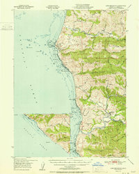
1951 Map of Cape Mendocino
USGS Topo · Published 1951About this map
Cape Mendocino stands as the westernmost point of California, where the land drops sharply into the Pacific Ocean amid a landscape of complex ridges and coastal gulches. This survey, mapped by the Army Map Service, captures the isolated character of the Lost Coast area before extensive modern development. Small settlements like Capetown and Petrolia serve as the primary hubs for a ranching economy, evidenced by landmarks such as Bonanza Ranch and Green Pond Ranch.
Find a feature on this map
112 named features on this map. Tap any name to fly to it.
Don’t see what you’re looking for? This feature index may not catch every label — zoom into the map to look around manually.
Map Details
Editions of this 1951 Cape Mendocino Map
2 editions found

Other maps of this area

1916 · Cape Fortunas
USGS Topo · 1:62,500

1919 · Glynn
USGS Topo · 1:62,500

1920 · Pt. Delagda
USGS Topo · 1:62,500

1921 · Cape Mendocino
USGS Topo · 1:62,500

1926 · Gorda
USGS Topo · 1:62,500

1943 · Ferndale
USGS Topo · 1:62,500

1944 · Fortuna
USGS Topo · 1:62,500

1949 · Eureka
USGS Topo · 1:250,000

1949 · Point Delgada
USGS Topo · 1:62,500

1950 · Cape Mendocino
USGS Topo · 1:62,500