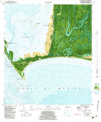
1982 Map of Cape San Blas
USGS Topo · Published 1984About this map
Cape San Blas anchors this coastal study, marking the sharp southern bend where the St Joseph Peninsula meets the Gulf of Mexico. This 1982 orthophotomap provides an hybrid view of the shifting shoreline, noting an area subject to frequent change south of the cape and the intricate marshes of St Joseph Bay. The landscape is defined by federal and military presence, including the U S Coast Guard Station with its lighthouse and radio tower, and the Eglin Air Force Base (Test Site) stretching across the dunes. To the east, the map details the narrow Indian Peninsula and the small settlements of Camp Palm and a nearby Trailer Park. Significant environmental features include the St Vincent National Wildlife Refuge and the winding waters of Money Bayou and Depot Creek.
Find a feature on this map
29 named features on this map. Tap any name to fly to it.
Don’t see what you’re looking for? This feature index may not catch every label — zoom into the map to look around manually.
Map Details
Editions of this 1982 Cape San Blas Map
Other maps of this area

1943 · St Joseph Spit
USGS Topo · 1:31,680

1943 · Port St. Joe
USGS Topo · 1:31,680

1943 · Cape San Blas
USGS Topo · 1:31,680

1943 · Indian Pass
USGS Topo · 1:24,000

1945 · Lake Wimico
USGS Topo · 1:31,680

1945 · Indian Pass
USGS Topo · 1:31,680

1945 · St Joseph Point
USGS Topo · 1:31,680

1949 · Apalachicola
USGS Topo · 1:250,000

1957 · Apalachicola
USGS Topo · 1:250,000

1959 · Apalachicola
USGS Topo · 1:250,000