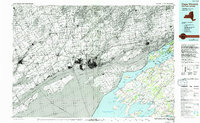
1985 Map of Cape Vincent
USGS Topo · Published 1994About this map
Kingston and the surrounding borderlands of the St Lawrence River define this mid-1980s topography. This map documents a complex maritime and riparian landscape where the river meets Lake Ontario, featuring large landmasses like Wolfe Island, Amherst Island, and Wellesley Island. The international boundary weaves through the Thousand Islands, separating the urban center of Kingston from New York settlements like Cape Vincent and Clayton.
Find a feature on this map
70 named features on this map. Tap any name to fly to it.
Don’t see what you’re looking for? This feature index may not catch every label — zoom into the map to look around manually.
Map Details
Editions of this 1985 Cape Vincent Map
2 editions found
Other maps of this area

1893 · Sackets Harbor
USGS Topo · 1:62,500

1895 · Sacketts Harbor
USGS Topo · 1:62,500

1895 · Stony Island
USGS Topo · 1:62,500

1895 · Watertown
USGS Topo · 1:62,500

1895 · Cape Vincent
USGS Topo · 1:62,500

1898 · Watertown
USGS Topo · 1:62,500

1900 · Clayton
USGS Topo · 1:62,500

1903 · Grindstone
USGS Topo · 1:62,500

1903 · Clayton
USGS Topo · 1:62,500

1903 · Alexandria Bay
USGS Topo · 1:62,500