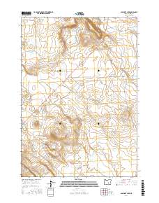
2017 Map of Capehart Lake
USGS Topo · Published 2017About this map
Capehart Lake and the isolated Yellowstone Waterhole define the water resources in this arid high-desert landscape of Harney County. The area is largely structured by the Public Land Survey System, with the map clearly delineating the transitions between t24s r26e, t24s r27e, t25s r26e, and t25s r27e. Human presence is minimal and defined by long-distance infrastructure, notably the path of Placidia Butte Rd which cuts through the sagebrush-spotted terrain. This late-2010s survey captures the region's character as a managed rangeland, where named water points are essential landmarks for land management and navigation across wide township sections.
Find a feature on this map
7 named features on this map. Tap any name to fly to it.
Don’t see what you’re looking for? This feature index may not catch every label — zoom into the map to look around manually.
Map Details
Editions of this 2017 Capehart Lake Map
This is the sole edition of this map. No revisions or reprints were ever made.
Other maps of this area

1955 · Burns
USGS Topo · 1:250,000

1958 · Burns
USGS Topo · 1:250,000

1959 · Burns
USGS Topo · 1:250,000

1979 · Moon Reservoir
USGS Topo · 1:24,000

1980 · Capehart Lake
USGS Topo · 1:24,000

1980 · Squaw Butte
USGS Topo · 1:24,000

1980 · Iron Mtn. Flat
USGS Topo · 1:24,000

1980 · Alec Butte
USGS Topo · 1:24,000

1980 · Lake on The Trail
USGS Topo · 1:24,000
1981 · Oakerman Lakes
USGS Topo · 1:24,000