
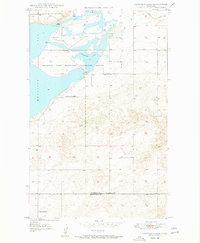
1948 Map of Capeneys Lake
USGS Topo · Published 1948About this map
Medicine Lake Migratory Waterfowl Refuge dominates the landscape of this northeastern Montana region, representing a significant conservation effort in the late 1940s. The survey illustrates the critical hydrologic connection between Medicine Lake and Capeneys Lake, showing the intricate shoreline and marshy terrain vital to local wildlife. This was a period when the Bureau of Reclamation and Geological Survey closely monitored these prairie wetlands for both agricultural and ecological purposes.
Find a feature on this map
10 named features on this map. Tap any name to fly to it.
Don’t see what you’re looking for? This feature index may not catch every label — zoom into the map to look around manually.
Map Details
Editions of this 1948 Capeneys Lake Map
2 editions found
Other maps of this area

1946 · Dagmar
USGS Topo · 1:24,000

1947 · Capeneys Lake
USGS Topo · 1:24,000

1948 · Dagmar
USGS Topo · 1:24,000

1948 · Reserve SE
USGS Topo · 1:24,000

1948 · Sunnyhill School
USGS Topo · 1:24,000

1948 · Medicine Lake
USGS Topo · 1:24,000

1948 · Reserve
USGS Topo · 1:24,000

1949 · Reserve SE
USGS Topo · 1:24,000

1949 · Sunnyhill School
USGS Topo · 1:24,000

1949 · Reserve
USGS Topo · 1:24,000