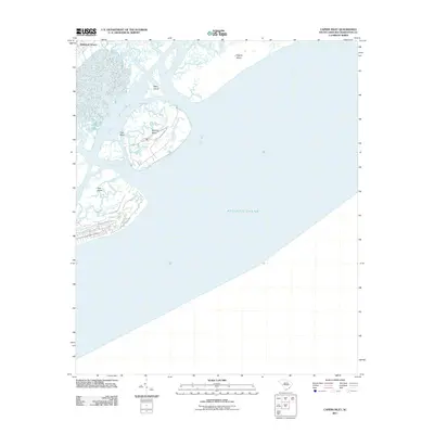
2011 Map of Capers Inlet
USGS Topo · Published 2011About this map
Dewees Island and its surrounding coastal barrier system dominate this maritime survey of the South Carolina coast. The map illustrates a complex network of tidal waterways and sandbars, where Horsebend Creek carves through the interior marsh of the islands before meeting the Atlantic Ocean at Dewees Inlet. While much of the area consists of undeveloped marsh and barrier landforms like Capers Island and Mary Island, the northwestern corner shows the established residential footprint of Whitehall Terrace. This document captures the dynamic nature of the Lowcountry shoreline, showing the relative isolation of Pine Island and the shifting shoals of Crab Bank during the early 21st century. It serves as a clear record of the interface between the mainland edge and the protected sea islands prior to more recent coastal changes.
Find a feature on this map
9 named features on this map. Tap any name to fly to it.
Don’t see what you’re looking for? This feature index may not catch every label — zoom into the map to look around manually.
Map Details
Editions of this 2011 Capers Inlet Map
This is the sole edition of this map. No revisions or reprints were ever made.
Other maps of this area

1919 · The Jetties
USGS Topo · 1:21,120

1919 · Capers Island
USGS Topo · 1:21,120

1919 · Wando
USGS Topo · 1:21,120

1919 · Fort Moultrie
USGS Topo · 1:21,120

1919 · Bulls Island
USGS Topo · 1:21,120

1919 · Sewee Bay
USGS Topo · 1:21,120

1943 · Capers Island
USGS Topo · 1:24,000

1943 · Fort Moultrie
USGS Topo · 1:24,000

1943 · Wando
USGS Topo · 1:24,000

1943 · Sewee Bay
USGS Topo · 1:24,000