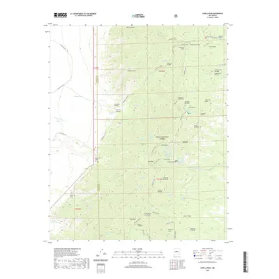
2020 Map of Capilla Peak
USGS Topo · Published 2020About this map
The Manzano Mountains dominate this high-altitude terrain in the modern era, where the sharp ridgeline of the Manzano Crest serves as a natural divide within the Cibola National Forest. The landscape is defined by its complex drainage network, where numerous springs such as Whisky Spring, Crow Spring, and Capilla Spring provided essential water sources in an otherwise arid environment. The map details a transition from the rugged eastern slopes, marked by features like Capilla Peak and Osha Peak, down into the deep incisions of Comanche Canyon and Cañon de la Capilla. Human presence is evidenced primarily by Forest Service infrastructure and backcountry routes, including the Rio del Oro Loop and the Torreon Tajique Loop Rd, which navigate the steep grades of Comanche Pass and Comanche Ridge.
Find a feature on this map
76 named features on this map. Tap any name to fly to it.
Don’t see what you’re looking for? This feature index may not catch every label — zoom into the map to look around manually.
Map Details
Editions of this 2020 Capilla Peak Map
This is the sole edition of this map. No revisions or reprints were ever made.
Other maps of this area

1917 · Estancia
USGS Topo · 1:125,000

1952 · Tome SE
USGS Topo · 1:24,000

1952 · Tome NE
USGS Topo · 1:24,000

1952 · Los Lunas SE
USGS Topo · 1:24,000

1954 · Bosque Peak
USGS Topo · 1:24,000

1954 · Capilla Peak
USGS Topo · 1:24,000

1954 · Torreon
USGS Topo · 1:24,000

1954 · Tajique
USGS Topo · 1:24,000

1954 · Torreon
USGS Topo · 1:62,500

1954 · Socorro
USGS Topo · 1:250,000