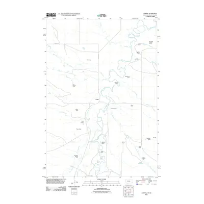
2011 Map of Capitol
USGS Topo · Published 2011About this map
The Little Missouri River snakes through this high plains landscape of Carter County, Montana, carving deep meanders and named bends such as Harring Bend and Johnson Bend. The small settlement of Capitol serves as a central point, supported by agricultural and ranching infrastructure including the Oleson Ranch and Rex Davis Ranch. Water management is critical in this arid region, evidenced by numerous named draws and reservoirs like Davis Reservoir, which is fed by Forty-eight Mile Creek.
Find a feature on this map
39 named features on this map. Tap any name to fly to it.
Don’t see what you’re looking for? This feature index may not catch every label — zoom into the map to look around manually.
Map Details
Editions of this 2011 Capitol Map
This is the sole edition of this map. No revisions or reprints were ever made.
Other maps of this area

1935 · Harding
USGS Topo · 1:125,000

1935 · Buffalo
USGS Topo · 1:125,000

1954 · Lemmon
USGS Topo · 1:250,000

1954 · Ekalaka
USGS Topo · 1:250,000

1956 · Ekalaka
USGS Topo · 1:250,000

1957 · Lemmon
USGS Topo · 1:250,000

1958 · Ekalaka
USGS Topo · 1:250,000

1965 · Ekalaka
USGS Topo · 1:250,000
1977 · Camp Crook
USGS Topo · 1:24,000
1978 · J K Butte
USGS Topo · 1:24,000