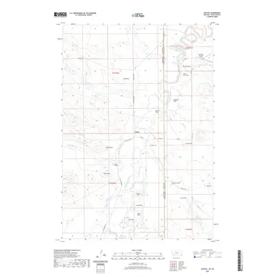
2020 Map of Capitol
USGS Topo · Published 2020About this map
Capitol serves as the focal point for this high-plains landscape where the Little Missouri River meanders through a series of pronounced oxbows and named river bends. This contemporary survey records the rural community at the edge of the Montana-South Dakota state line, characterized by its wide-ranging ranching infrastructure and land markers such as Indian Butte and Three Peaks. The mapping of local family and community history is anchored by the Capitol Church Cem and the nearby Capitol Cem, alongside several named draws and hills that define the drainage basins of Tie Cr and Sand Cr. Cultural landmarks like the Sky Ranch For Boys Airport stand out against the terrain of Mud Butte and The Island, a unique landform carved by the shifting river. The grid of section lines and roads such as Camp Crook Rd and Little Missouri Rd reflect the enduring homesteading patterns of Carter County.
Find a feature on this map
45 named features on this map. Tap any name to fly to it.
Don’t see what you’re looking for? This feature index may not catch every label — zoom into the map to look around manually.
Map Details
Editions of this 2020 Capitol Map
This is the sole edition of this map. No revisions or reprints were ever made.
Other maps of this area

1935 · Harding
USGS Topo · 1:125,000

1935 · Buffalo
USGS Topo · 1:125,000

1954 · Lemmon
USGS Topo · 1:250,000

1954 · Ekalaka
USGS Topo · 1:250,000

1956 · Ekalaka
USGS Topo · 1:250,000

1957 · Lemmon
USGS Topo · 1:250,000

1958 · Ekalaka
USGS Topo · 1:250,000

1965 · Ekalaka
USGS Topo · 1:250,000
1977 · Camp Crook
USGS Topo · 1:24,000
1978 · J K Butte
USGS Topo · 1:24,000