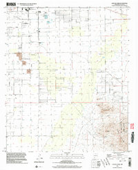
1996 Map of Capitol Dome
USGS Topo · Published 2003About this map
Rock Hound State Park anchors the southeastern corner of this high-desert landscape, where the rugged peaks of the Florida Mountains rise sharply above the basin floor. The terrain transition is marked by geological landmarks such as Navajo Bill Hill and the prominent Capitol Dome, which overlooks a series of drainages including Mexican Canyon and Spring Canyon. These features provide a stark contrast to the gridded desert plains to the north and west.
Find a feature on this map
23 named features on this map. Tap any name to fly to it.
Don’t see what you’re looking for? This feature index may not catch every label — zoom into the map to look around manually.
Map Details
Editions of this 1996 Capitol Dome Map
This is the sole edition of this map. No revisions or reprints were ever made.
Other maps of this area

1899 · Deming
USGS Topo · 1:125,000

1915 · Deming
USGS Topo · 1:125,000

1955 · Las Cruces
USGS Topo · 1:250,000

1958 · Las Cruces
USGS Topo · 1:250,000

1964 · Gym Peak
USGS Topo · 1:24,000

1964 · Deming West
USGS Topo · 1:24,000

1964 · Florida Gap
USGS Topo · 1:24,000

1965 · South Peak
USGS Topo · 1:24,000

1965 · Deming East
USGS Topo · 1:24,000
1965 · Midway Butte
USGS Topo · 1:24,000