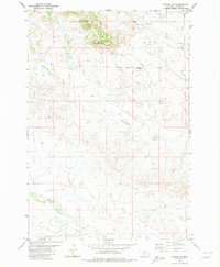
1980 Map of Capitol NW
USGS Topo · Published 1980About this map
Sheep Mountain rises above the drainage networks of Carter County in this 1980 survey, showing the complex topography of the Montana plains. The landscape is defined by the convergence of several intermittent waterways, most notably Hackberry Creek and Cottonwood Creek, which illustrate the natural drainage patterns of this high-plains environment. This area, largely defined by its township and range boundaries including R 61 E and R 62 E, remains relatively sparse of permanent structures, reflecting the large-scale ranching and grazing land typical of the region's late-twentieth-century geography. Small landmarks like Sand Butte Sub provide localized elevation points among the winding courses of Sand Creek and Bull Creek, offering a detailed record of the terrain as it existed before contemporary land-use changes.
Find a feature on this map
8 named features on this map. Tap any name to fly to it.
Don’t see what you’re looking for? This feature index may not catch every label — zoom into the map to look around manually.
Map Details
Editions of this 1980 Capitol NW Map
This is the sole edition of this map. No revisions or reprints were ever made.
Other maps of this area

1954 · Ekalaka
USGS Topo · 1:250,000

1956 · Ekalaka
USGS Topo · 1:250,000

1958 · Ekalaka
USGS Topo · 1:250,000

1965 · Ekalaka
USGS Topo · 1:250,000
1980 · Capitol Rock
USGS Topo · 1:24,000

1980 · Cactus Creek West
USGS Topo · 1:24,000

1980 · Finger Buttes East
USGS Topo · 1:24,000

1980 · Belltower Butte
USGS Topo · 1:24,000
1980 · Lone Tree Creek
USGS Topo · 1:24,000
1980 · Timber Hill
USGS Topo · 1:24,000