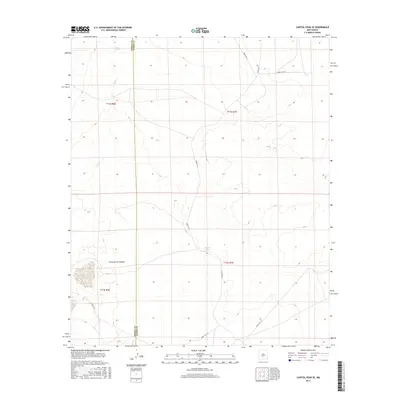
2017 Map of Capitol Peak SE
USGS Topo · Published 2017About this map
Salina de San Andres dominates the southwestern quadrant of this arid landscape, a prominent salt flat within the Tularosa Basin. This 2017 survey by the U.S. Geological Survey documents a region defined by restricted access and hydraulic features, as indicated by numerous White Sands Missile Range (WSMR) routes. The intermittent flow of Salt Cr, which originates near Salt Springs in the northwest, highlights the complex drainage patterns of this high-desert environment. Further east, Malpais Spring provides a critical water source on the edge of the volcanic terrain. The boundary between Sierra and Otero counties runs vertically through the western portion of the sheet, dividing these basins and ranges. The network of service roads, including Wsmr P Rt 9 and Wsmr S Rt 314, illustrates the logistical infrastructure required for this military and research landscape.
Find a feature on this map
15 named features on this map. Tap any name to fly to it.
Don’t see what you’re looking for? This feature index may not catch every label — zoom into the map to look around manually.
Map Details
Editions of this 2017 Capitol Peak SE Map
This is the sole edition of this map. No revisions or reprints were ever made.
Other maps of this area

1916 · Tularosa
USGS Topo · 1:125,000

1947 · Three Rivers
USGS Topo · 1:62,500

1947 · Capitol Peak
USGS Topo · 1:62,500

1948 · Lumley Lake
USGS Topo · 1:62,500

1948 · Tularosa
USGS Topo · 1:62,500

1954 · Tularosa
USGS Topo · 1:250,000

1958 · Tularosa
USGS Topo · 1:250,000

1981 · Tularosa
USGS Topo · 1:100,000
1981 · Three Rivers SW
USGS Topo · 1:24,000
1981 · Sheep Mountain
USGS Topo · 1:24,000