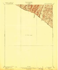
1916 Map of Capon Bridge
USGS Topo · Published 1920About this map
Cacapon Mountain and Warm Spring Ridge dominate this corner of the Potomac Highlands during the early twentieth century. The map illustrates a landscape of parallel ridges and narrow valleys along the West Virginia Virginia border, where small settlements like Largent and Ungers Store serve as local hubs. This preliminary edition, based on a 1914 survey by E.I. Ireland and C.W. Arnold, reveals the rural social structure through its network of district schools. Educational landmarks such as Enon School, Birch Grove School, and Timber Ridge School are situated to serve isolated mountain communities, reflecting the era's reliance on localized public services before widespread school consolidation. The winding course of the Cacapon River cuts through Sideling Hill, creating a natural corridor that shaped the early transport and settlement patterns of Morgan and Hampshire counties.
Find a feature on this map
22 named features on this map. Tap any name to fly to it.
Don’t see what you’re looking for? This feature index may not catch every label — zoom into the map to look around manually.
Map Details
Editions of this 1916 Capon Bridge Map
2 editions found

Other maps of this area

1891 · Romney
USGS Topo · 1:125,000

1894 · Winchester
USGS Topo · 1:125,000

1898 · Paw Paw
USGS Topo · 1:62,500

1899 · Flintstone
USGS Topo · 1:62,500

1899 · Hancock
USGS Topo · 1:62,500

1900 · Pawpaw
USGS Topo · 1:62,500

1900 · Flintstone
USGS Topo · 1:62,500

1901 · Hancock
USGS Topo · 1:62,500

1910 · Paw Paw
USGS Topo · 1:62,500

1914 · Gerrardstown
USGS Topo · 1:48,000