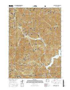
2017 Map of Carberry Creek
USGS Topo · Published 2017About this map
Steamboat sits in the narrow valley of Carberry Creek, serving as a focal point for the mountain drainage systems of the Rogue River National Forest. This 2017 survey shows the high-elevation terrain along the Oregon-California border, where the Siskiyou Mountains transition into the Cascades. Local history is anchored at the Steamboat Cem, while the southern reaches of the map highlight the reservoir at Applegate Lake. The landscape is defined by deep drainages and named ridges like Bearwallow Ridge and Elliott Creek Ridge, as well as numerous gulches such as China Gulch and Sawmill Gulch. The settlement of Copper marks a historic location near the lake's edge, while various Forest Service roads, including Nat For Dev Rd 10, provide the primary access through this heavily timbered region.
Find a feature on this map
73 named features on this map. Tap any name to fly to it.
Don’t see what you’re looking for? This feature index may not catch every label — zoom into the map to look around manually.
Map Details
Editions of this 2017 Carberry Creek Map
This is the sole edition of this map. No revisions or reprints were ever made.
Other maps of this area

1908 · Grants Pass
USGS Topo · 1:125,000

1914 · Seiad
USGS Topo · 1:125,000

1922 · Seiad
USGS Topo · 1:125,000

1948 · Weed
USGS Topo · 1:250,000

1950 · Weed
USGS Topo · 1:250,000

1954 · Oregon Caves
USGS Topo · 1:62,500

1954 · Ruch
USGS Topo · 1:62,500

1955 · Seiad Valley
USGS Topo · 1:62,500

1955 · Medford
USGS Topo · 1:250,000

1956 · Happy Camp
USGS Topo · 1:62,500