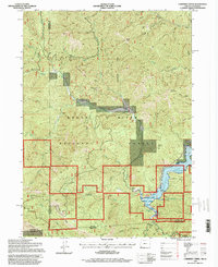
1996 Map of Carberry Creek
USGS Topo · Published 1998About this map
Rogue River National Forest defines the rugged borderlands of Southern Oregon in this mid-1990s survey. The landscape is deeply etched by the Applegate River and its numerous tributaries, including Carberry Creek, which flows into the expansive Applegate Lake. Local industry and settlement history are marked by the presence of the Steamboat Mine, the Jay Bird Mine, and an Open Pit Mine in the northern hills. The area around the Steamboat (Site) and nearby Cem reflects the legacy of earlier habitation, while Steamboat Ranch and Baker Flat represent the continuing human footprint. To the south, the terrain rises toward Stricklin Butte as the map tracks the administrative boundaries where Jackson and Siskiyou counties meet at the Oregon-California state line.
Find a feature on this map
53 named features on this map. Tap any name to fly to it.
Don’t see what you’re looking for? This feature index may not catch every label — zoom into the map to look around manually.
Map Details
Editions of this 1996 Carberry Creek Map
This is the sole edition of this map. No revisions or reprints were ever made.
Other maps of this area

1908 · Grants Pass
USGS Topo · 1:125,000

1914 · Seiad
USGS Topo · 1:125,000

1922 · Seiad
USGS Topo · 1:125,000

1948 · Weed
USGS Topo · 1:250,000

1950 · Weed
USGS Topo · 1:250,000

1954 · Oregon Caves
USGS Topo · 1:62,500

1954 · Ruch
USGS Topo · 1:62,500

1955 · Seiad Valley
USGS Topo · 1:62,500

1955 · Medford
USGS Topo · 1:250,000

1956 · Happy Camp
USGS Topo · 1:62,500