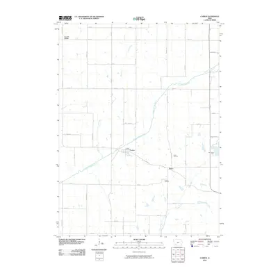
2010 Map of Carbon
USGS Topo · Published 2010About this map
The Middle Nodaway River winds through this rural landscape of Adams County, anchoring the settlement of Carbon. The river is joined by several tributaries, including Bull Creek and Show Creek, reflecting a well-drained agricultural terrain. Historically centered around the Carbon Post Office, this area demonstrates a transition from earlier settlement patterns to a modern grid of county roads.
Find a feature on this map
39 named features on this map. Tap any name to fly to it.
Don’t see what you’re looking for? This feature index may not catch every label — zoom into the map to look around manually.
Map Details
Editions of this 2010 Carbon Map
This is the sole edition of this map. No revisions or reprints were ever made.
Other maps of this area

1954 · Omaha
USGS Topo · 1:250,000

1955 · Nebraska City
USGS Topo · 1:250,000

1957 · Nebraska City
USGS Topo · 1:250,000

1957 · Omaha
USGS Topo · 1:250,000

1958 · Omaha
USGS Topo · 1:250,000

1958 · Nebraska City
USGS Topo · 1:250,000

1980 · Corning South
USGS Topo · 1:24,000

1980 · Corning North
USGS Topo · 1:24,000

1980 · Grant
USGS Topo · 1:24,000
1980 · Brooks
USGS Topo · 1:24,000