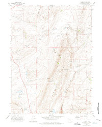
1971 Map of Carbon
USGS Topo · Published 1975About this map
Carbon sits at the northeastern edge of this landscape, its presence defined by an Old Railroad Grade and a nearby Cem, reflecting its origins as a nineteenth-century coal mining hub along the Union Pacific route. The terrain is characterized by the high elevations of Hi Allen Ridge and the Sand Hills, transitioning into the expansive basin where Percy and the Soda Lakes are located.
Find a feature on this map
36 named features on this map. Tap any name to fly to it.
Don’t see what you’re looking for? This feature index may not catch every label — zoom into the map to look around manually.
Map Details
Editions of this 1971 Carbon Map
This is the sole edition of this map. No revisions or reprints were ever made.
Other maps of this area

1893 · Fort Steele
USGS Topo · 1:125,000

1914 · Hanna
USGS Topo · 1:62,500

1914 · Saddleback Hills
USGS Topo · 1:62,500

1921 · Saddleback Hills
USGS Topo · 1:62,500

1954 · Rawlins
USGS Topo · 1:250,000

1955 · Elk Mountain
USGS Topo · 1:24,000

1955 · Rattlesnake Pass
USGS Topo · 1:24,000

1958 · Rawlins
USGS Topo · 1:250,000

1958 · T L Ranch
USGS Topo · 1:24,000

1962 · Rawlins
USGS Topo · 1:250,000