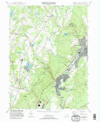
1994 Map of Carbondale
USGS Topo · Published 1995About this map
The Lackawanna River corridor serves as the industrial and civic spine of this region, anchoring the dense settlements of Carbondale, Mayfield, and Jermyn. The map reveals a landscape balancing heavy industry with public recreation, where a Strip Mine and gravel pits sit adjacent to the unique geological formation of Archbald Pothole State Park. The plateau to the west is dotted with smaller communities like Tompkinsville and Montdale, along with prominent water bodies such as Chapman Lake and Heart Lake. Religious and community life is well-documented through numerous sites including Finch Hill Ch, Corpus Christi Ch, and several family and parish burial grounds like Scott Valley Cem and Our Mother of Sorrows Cem. The presence of the Roosevelt Highway and the Voc Tech Sch reflects the region's mid-century infrastructural development and educational focus.
Find a feature on this map
72 named features on this map. Tap any name to fly to it.
Don’t see what you’re looking for? This feature index may not catch every label — zoom into the map to look around manually.
Map Details
Editions of this 1994 Carbondale Map
This is the sole edition of this map. No revisions or reprints were ever made.
Other maps of this area

1889 · Scranton
USGS Topo · 1:62,500

1891 · Scranton
USGS Topo · 1:62,500

1892 · Honesdale
USGS Topo · 1:62,500

1892 · Dundaff
USGS Topo · 1:62,500

1893 · Scranton
USGS Topo · 1:62,500

1928 · Ariel
USGS Topo · 1:62,500

1932 · Ariel
USGS Topo · 1:62,500

1943 · Scranton
USGS Topo · 1:125,000

1943 · Honesdale
USGS Topo · 1:125,000

1946 · Dalton
USGS Topo · 1:24,000