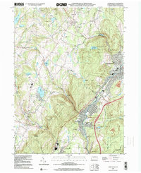
1999 Map of Carbondale
USGS Topo · Published 2001About this map
The Lackawanna River corridor serves as the industrial and social backbone of this region at the end of the millennium, anchoring a chain of valley settlements from Carbondale and Mayfield south through Jermyn and Archbald. The landscape is a complex mix of heavy industry and civic life, where the Delaware and Hudson rail line skirts former mine workings and modern utility infrastructure like the Sewage Disposal Plant. Away from the river valley, the terrain rises into the highlands of Meyers Mtn and Cary Mountain, where recreational spaces such as Merli-Sarnoski County Park and the unique geological site at Archbald Pothole State Park provide a counterpoint to the urban density. Genealogists will find a high concentration of burial sites, including Our Mother of Sorrows Cem and Sandy Bank Cem, which reflect the long-standing ethnic and religious communities of the anthracite coal region.
Find a feature on this map
68 named features on this map. Tap any name to fly to it.
Don’t see what you’re looking for? This feature index may not catch every label — zoom into the map to look around manually.
Map Details
Editions of this 1999 Carbondale Map
This is the sole edition of this map. No revisions or reprints were ever made.
Other maps of this area

1889 · Scranton
USGS Topo · 1:62,500

1891 · Scranton
USGS Topo · 1:62,500

1892 · Honesdale
USGS Topo · 1:62,500

1892 · Dundaff
USGS Topo · 1:62,500

1893 · Scranton
USGS Topo · 1:62,500

1928 · Ariel
USGS Topo · 1:62,500

1932 · Ariel
USGS Topo · 1:62,500

1943 · Scranton
USGS Topo · 1:125,000

1943 · Honesdale
USGS Topo · 1:125,000

1946 · Dalton
USGS Topo · 1:24,000