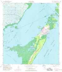
1956 Map of Card Sound
USGS Topo · Published 1970About this map
Key Largo and the surrounding island chains of the Florida Keys are shown here during a period of transition, with early developments like Grayvik and the Ocean Reef Club emerging amidst the mangrove swamps and tidal creeks. The map illustrates the complex waterway network between Card Sound and the Atlantic Ocean, including the Intracoastal Waterway and the narrow passages of Angelfish Creek and Broad Creek.
Find a feature on this map
53 named features on this map. Tap any name to fly to it.
Don’t see what you’re looking for? This feature index may not catch every label — zoom into the map to look around manually.
Map Details
Editions of this 1956 Card Sound Map
5 editions found

Other maps of this area

1947 · Garden Cove
USGS Topo · 1:24,000

1947 · Blackwater Sound
USGS Topo · 1:24,000

1949 · Blackwater Sound
USGS Topo · 1:24,000

1949 · Garden Cove
USGS Topo · 1:24,000

1949 · Elliott Key
USGS Topo · 1:24,000

1949 · Card Sound
USGS Topo · 1:24,000

1949 · Pacific Reef
USGS Topo · 1:24,000

1949 · Arsenicker Keys
USGS Topo · 1:24,000

1950 · Homestead
USGS Topo · 1:24,000

1950 · Glades
USGS Topo · 1:24,000