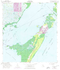
1956 Map of Card Sound
USGS Topo · Published 1974About this map
Key Largo and the surrounding shallow sounds represent a transition between the Florida mainland and the outer reef tract during the mid-20th century. Photorevised updates from 1969 and 1973 reveal the rapid development of the Ocean Reef Club and the settlement of Grayvik, where a sprawling Golf Course and residential canals have been carved into the tropical landscape. The interior of the northern key remains dominated by Crocodile Lake and dense mangroves, while the waters are navigated via the Intracostal Waterway and various passages like Jewfish Creek and Steamboat Creek. To the north, the map details the boundary between Dade and Monroe counties as it cuts through Card Sound. This survey captures the infrastructure of the era, including the Toll Bridge connecting the mainland, and the isolation of nearby islands like Pumpkin Key and Old Rhodes Key.
Find a feature on this map
47 named features on this map. Tap any name to fly to it.
Don’t see what you’re looking for? This feature index may not catch every label — zoom into the map to look around manually.
Map Details
Editions of this 1956 Card Sound Map
5 editions found

Other maps of this area

1947 · Garden Cove
USGS Topo · 1:24,000

1947 · Blackwater Sound
USGS Topo · 1:24,000

1949 · Blackwater Sound
USGS Topo · 1:24,000

1949 · Garden Cove
USGS Topo · 1:24,000

1949 · Elliott Key
USGS Topo · 1:24,000

1949 · Card Sound
USGS Topo · 1:24,000

1949 · Pacific Reef
USGS Topo · 1:24,000

1949 · Arsenicker Keys
USGS Topo · 1:24,000

1950 · Homestead
USGS Topo · 1:24,000

1950 · Glades
USGS Topo · 1:24,000