
1946 Map of Cardiff
USGS Topo · Published 1946About this map
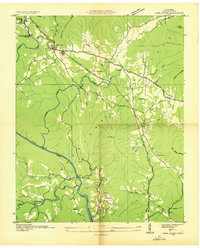
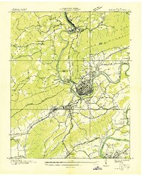
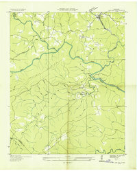
Rockwood and the small settlement of Cardiff anchor the southeastern corner of this mid-century landscape, where the Southern railroad and the Broadway of America highway trace the foot of Walden Ridge. The terrain is defined by the massive uplift of the Cumberland Plateau and the Crab Orchard Mountains, creating a complex network of gaps and hollows that historically dictated local travel. This 1946 examination shows a community deeply integrated with its geography, seen in the placement of rural institutions like Hatley Sch, Moulders Sch, and Mt Pisgah Ch.
Find a feature on this map
80 named features on this map. Tap any name to fly to it.
Don’t see what you’re looking for? This feature index may not catch every label — zoom into the map to look around manually.
Map Details
Editions of this 1946 Cardiff Map
This is the sole edition of this map. No revisions or reprints were ever made.
Other maps of this area

1887 · Kingston
USGS Topo · 1:125,000

1891 · Kingston
USGS Topo · 1:125,000

1893 · Kingston
USGS Topo · 1:125,000

1895 · Wartburg
USGS Topo · 1:125,000

1896 · Wartburg
USGS Topo · 1:125,000

1935 · Rockwood
USGS Topo · 1:24,000
1935 · Camp Austin
USGS Topo · 1:24,000
1935 · Harriman
USGS Topo · 1:24,000
1935 · Lancing
USGS Topo · 1:24,000

1936 · Hebbertsburg
USGS Topo · 1:24,000