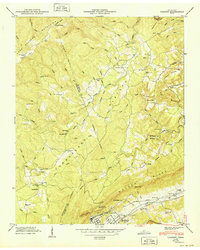
1949 Map of Cardiff
USGS Topo · Published 1949About this map
Rockwood and the industrial-era town of Cardiff anchor the southeastern corner of this study, positioned where the industrial corridor of the Tennessee Central and Southern railroads meet the sharp ascent of Walden Ridge. The landscape transitions from these rail-served valley settlements into the uplifted Cumberland Plateau and the Crab Orchard Mountains to the northwest. This rugged topography dictated a dispersed settlement pattern, visible in the string of rural community centers like Mt Pisgah Ch and Hatley Sch located along the winding branches of Crab Orchard Creek.
Find a feature on this map
52 named features on this map. Tap any name to fly to it.
Don’t see what you’re looking for? This feature index may not catch every label — zoom into the map to look around manually.
Map Details
Editions of this 1949 Cardiff Map
This is the sole edition of this map. No revisions or reprints were ever made.
Other maps of this area

1887 · Kingston
USGS Topo · 1:125,000

1891 · Kingston
USGS Topo · 1:125,000

1893 · Kingston
USGS Topo · 1:125,000

1895 · Wartburg
USGS Topo · 1:125,000

1896 · Wartburg
USGS Topo · 1:125,000

1935 · Rockwood
USGS Topo · 1:24,000

1935 · Camp Austin
USGS Topo · 1:24,000

1935 · Harriman
USGS Topo · 1:24,000

1935 · Lancing
USGS Topo · 1:24,000

1936 · Hebbertsburg
USGS Topo · 1:24,000