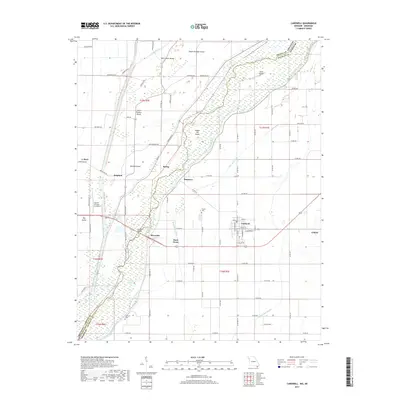
2017 Map of Cardwell
USGS Topo · Published 2017About this map
Cardwell and Arbyrd anchor the southeastern corner of this survey, situated where the Missouri Bootheel meets the Arkansas state line. This drainage-dependent landscape is defined by the Saint Francis River, which winds through a complex system of islands and sloughs, including Indian Hill Island and Upper Panther Island. The reliance on water management is evident in the network of engineered channels like Mayo Ditch, Red Devil Ditch, and Mud Slough Ditch that crisscross the lowlands to reclaim agricultural land. Rural life is marked by small settlements such as Riverside, Buck Donic, and Hargrove, along with landmarks like Hopkins Bridge and Cochrans Opening. Genealogists may find the locations of Cochran Cem and Parsell Cem particularly useful, while aviation history is noted at the Hog Air Aviation Inc Airport north of the river.
Find a feature on this map
85 named features on this map. Tap any name to fly to it.
Don’t see what you’re looking for? This feature index may not catch every label — zoom into the map to look around manually.
Map Details
Editions of this 2017 Cardwell Map
This is the sole edition of this map. No revisions or reprints were ever made.
Other maps of this area

1934 · Kennett
USGS Topo · 1:62,500

1940 · Marmaduke
USGS Topo · 1:62,500

1940 · Kennett
USGS Topo · 1:62,500

1941 · Leachville
USGS Topo · 1:62,500

1941 · Manila
USGS Topo · 1:62,500

1953 · Memphis
USGS Topo · 1:250,000

1956 · Leachville
USGS Topo · 1:62,500

1956 · Kennett
USGS Topo · 1:62,500

1956 · Manila
USGS Topo · 1:62,500

1956 · Memphis
USGS Topo · 1:250,000