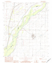
1983 Map of Cardwell
USGS Topo · Published 1984About this map
The St Francis River forms the central artery of this Missouri-Arkansas borderland, carving a complex network of islands and sloughs through the low-lying terrain of Buffalo township. Small agricultural settlements like Cardwell and Riverside anchor the eastern side of the river, while the landscape is defined by the braided channels and named landforms of the river bottom, including Bark Camp Island, Indian Hill, and Wilkins Island.
Find a feature on this map
26 named features on this map. Tap any name to fly to it.
Don’t see what you’re looking for? This feature index may not catch every label — zoom into the map to look around manually.
Map Details
Editions of this 1983 Cardwell Map
This is the sole edition of this map. No revisions or reprints were ever made.
Other maps of this area

1934 · Kennett
USGS Topo · 1:62,500

1940 · Marmaduke
USGS Topo · 1:62,500

1940 · Kennett
USGS Topo · 1:62,500

1941 · Leachville
USGS Topo · 1:62,500

1941 · Manila
USGS Topo · 1:62,500

1953 · Memphis
USGS Topo · 1:250,000

1956 · Leachville
USGS Topo · 1:62,500

1956 · Kennett
USGS Topo · 1:62,500

1956 · Manila
USGS Topo · 1:62,500

1956 · Memphis
USGS Topo · 1:250,000