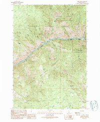
1989 Map of Carey Dome
USGS Topo · Published 1990About this map
The Salmon River carves a deep path through this 1989 Idaho interior, serving as the primary boundary between the Nez Perce National Forest and the Payette National Forest. This river corridor was a focal point for wilderness access and river travel in the late 1980s, evidenced by the Wind River Boat Ramp and the Vinegar Creek Boat Ramp. The mapping captures the wild character of the Frank Church River of No Return Wilderness and the Gospel Hump Wilderness, where infrastructure was limited to foot travel and pack trails. On the ridges above the river, traces of mineral exploration appear at the Bullion Mine and Big Three Mine, while high-altitude surveillance is centered at the Carey Dome Lookout. Isolated outposts like the McMeekin Ranch and Hackett Cabin signify the scattered human presence in this steep, forested landscape.
Find a feature on this map
43 named features on this map. Tap any name to fly to it.
Don’t see what you’re looking for? This feature index may not catch every label — zoom into the map to look around manually.
Map Details
Editions of this 1989 Carey Dome Map
This is the sole edition of this map. No revisions or reprints were ever made.
Other maps of this area

1931 · Buffalo Hump
USGS Topo · 1:125,000

1934 · Buffalo Hump
USGS Topo · 1:125,000

1938 · Riggins
USGS Topo · 1:96,000

1945 · Riggins
USGS Topo · 1:125,000

1955 · Grangeville
USGS Topo · 1:250,000

1956 · Burgdorf
USGS Topo · 1:62,500

1956 · Elk City
USGS Topo · 1:250,000

1959 · Grangeville
USGS Topo · 1:250,000

1960 · Elk City
USGS Topo · 1:250,000

1963 · Hanover Mtn.
USGS Topo · 1:24,000