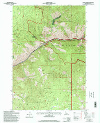
1995 Map of Carey Dome
USGS Topo · Published 1999About this map
The Salmon River cuts a deep canyon through this portion of central Idaho, separating the Nez Perce National Forest to the north from the Payette National Forest to the south. This rugged corridor is defined by the river's wild character, evidenced by Vinegar Creek Rapids and Chittam Rapids, as well as the narrow Wind River Pack Bridge connecting the high ridges. Evidence of historical high-elevation mining and pioneer habitation persists across the landscape, from the Big Three Mine and Bullion Mine to the solitary Grave and McMeekin Ranch near the Gospel Hump Wilderness boundary. To the south, the terrain rises toward Carey Dome, where a Lookout stands over a network of drainages including Carey Creek and Fall Creek. The convergence of these three major wilderness areas and the preservation of remote sites like Hackett Cabin reflect the area's transition into a protected backcountry during the late twentieth century.
Find a feature on this map
46 named features on this map. Tap any name to fly to it.
Don’t see what you’re looking for? This feature index may not catch every label — zoom into the map to look around manually.
Map Details
Editions of this 1995 Carey Dome Map
This is the sole edition of this map. No revisions or reprints were ever made.
Other maps of this area

1931 · Buffalo Hump
USGS Topo · 1:125,000

1934 · Buffalo Hump
USGS Topo · 1:125,000

1938 · Riggins
USGS Topo · 1:96,000

1945 · Riggins
USGS Topo · 1:125,000

1955 · Grangeville
USGS Topo · 1:250,000

1956 · Burgdorf
USGS Topo · 1:62,500

1956 · Elk City
USGS Topo · 1:250,000

1959 · Grangeville
USGS Topo · 1:250,000

1960 · Elk City
USGS Topo · 1:250,000

1963 · Hanover Mtn.
USGS Topo · 1:24,000