
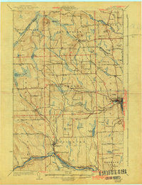
1932 Map of Caribou
USGS Topo · Published 1932About this map
The Madawaska River and Aroostook River define the drainage of this northeastern Maine landscape during the early 1930s. The settlement pattern reflects the area's agricultural and lumbering roots, with a dense network of country schools like Snowman Sch and Langlais Sch serving the townships of Woodland and New Sweden. The Bangor and Aroostook RR provides the primary industrial artery, connecting sidings such as Rista Siding and Ben Thomas Siding to larger hubs at Caribou and Washburn. This map is particularly valuable for genealogists, as it identifies numerous family-named schools and small cemeteries, including West Jemtland Cem and the Dempsey Ch. The inclusion of the Municipal Airport near Caribou signals the transition toward modern infrastructure, even as traditional landmarks like Goodwin Mill remain central to the local economy.
Find a feature on this map
107 named features on this map. Tap any name to fly to it.
Don’t see what you’re looking for? This feature index may not catch every label — zoom into the map to look around manually.
Map Details
Editions of this 1932 Caribou Map
2 editions found
Other maps of this area

1921 · Van Buren
USGS Topo · 1:250,000

1927 · Stockholm
USGS Topo · 1:48,000

1927 · Square Lake
USGS Topo · 1:48,000

1929 · Portage
USGS Topo · 1:62,500

1929 · Caribou
USGS Topo · 1:48,000

1930 · Fort Fairfield
USGS Topo · 1:48,000

1931 · Square Lake
USGS Topo · 1:62,500

1931 · Ashland
USGS Topo · 1:48,000

1931 · Van Buren
USGS Topo · 1:48,000

1931 · Portage
USGS Topo · 1:62,500