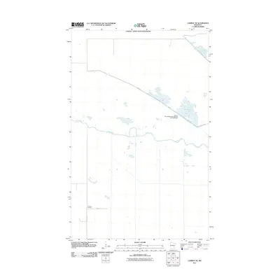
2011 Map of Caribou NE
USGS Topo · Published 2011About this map
The Canada - United States Boundary defines the northern edge of this northern Roseau County landscape, where the managed wetlands of the Roseau River Wildlife Management Area dominate the geography. Centered on the winding course of the Roseau River, the map shows a specialized hydrology designed for conservation, notably Pool 3 and the associated Roseau River Wildlife Management Area Pool3 Dam. Access through this remote wetland and prairie region is primarily via Dike Rd, which cuts diagonally across the terrain. While much of the area is dedicated to wildlife management, signs of local settlement and history appear in the southwest corner. Here, the intersection of 120th Ave and 340th St serves as a localized hub, most notably housing the Juneberry Cemetery, a significant site for family researchers and genealogists tracing roots in this borderland community.
Find a feature on this map
9 named features on this map. Tap any name to fly to it.
Don’t see what you’re looking for? This feature index may not catch every label — zoom into the map to look around manually.
Map Details
Editions of this 2011 Caribou NE Map
This is the sole edition of this map. No revisions or reprints were ever made.
Other maps of this area

1919 · Badger
USGS Topo · 1:62,500

1930 · Juneberry
USGS Topo · 1:31,680

1932 · Juneberry
USGS Topo · 1:62,500

1952 · Thief River Falls
USGS Topo · 1:250,000

1956 · Thief River Falls
USGS Topo · 1:250,000

1957 · Thief River Falls
USGS Topo · 1:250,000
1966 · Haug
USGS Topo · 1:24,000
1966 · Badger NW
USGS Topo · 1:24,000

1966 · Caribou
USGS Topo · 1:24,000
1966 · Juneberry Ridge
USGS Topo · 1:24,000