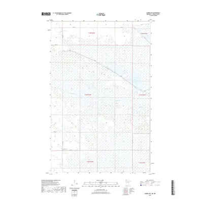
2019 Map of Caribou NE
USGS Topo · Published 2019About this map
Roseau River meanders through this low-lying region of northern Roseau County, defining a landscape dominated by wetlands and water management. The presence of Pool 3 and the extensive Dike Rd corridor suggests a highly controlled hydraulic environment, likely part of regional conservation or flood mitigation efforts. Human presence is sparse, marked primarily by a grid of rural section roads such as 410th St and 340th St. One of the most significant landmarks for local history and genealogy is the Juneberry Cem, located near the intersection of 340th St and 120th Ave. The map's layout, divided by the Public Land Survey System townships like t163n r44w, reflects the systematic organization of the Minnesota frontier into its modern rural character.
Find a feature on this map
15 named features on this map. Tap any name to fly to it.
Don’t see what you’re looking for? This feature index may not catch every label — zoom into the map to look around manually.
Map Details
Editions of this 2019 Caribou NE Map
This is the sole edition of this map. No revisions or reprints were ever made.
Other maps of this area

1919 · Badger
USGS Topo · 1:62,500

1930 · Juneberry
USGS Topo · 1:31,680

1932 · Juneberry
USGS Topo · 1:62,500

1952 · Thief River Falls
USGS Topo · 1:250,000

1956 · Thief River Falls
USGS Topo · 1:250,000

1957 · Thief River Falls
USGS Topo · 1:250,000
1966 · Haug
USGS Topo · 1:24,000
1966 · Badger NW
USGS Topo · 1:24,000

1966 · Caribou
USGS Topo · 1:24,000
1966 · Juneberry Ridge
USGS Topo · 1:24,000