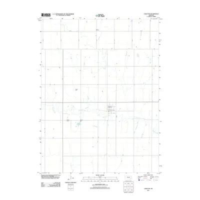
2011 Map of Carleton
USGS Topo · Published 2011About this map
Carleton serves as the central hub of this Thayer County landscape, where the Carleton Post Office and a grid of residential streets including 2nd St anchor the local community. The surrounding terrain is defined by the winding course of Big Sandy Creek, which meanders east-to-west across the central plains. Water management and local aviation are evident through features such as the Weddell Reservoir, secured by the Weddell Dam, and the nearby Lippitt Dam. For genealogists and local historians, the Summit Cemetery in the northern portion of the quadrangle provides a significant point of reference. The area maintains its rural character with the Folkerts Airport and a disciplined network of section-line roads like Road X and Road Y that facilitate transport across the agricultural heartland.
Find a feature on this map
18 named features on this map. Tap any name to fly to it.
Don’t see what you’re looking for? This feature index may not catch every label — zoom into the map to look around manually.
Map Details
Editions of this 2011 Carleton Map
This is the sole edition of this map. No revisions or reprints were ever made.
Other maps of this area

1898 · Hebron
USGS Topo · 1:125,000

1955 · Lincoln
USGS Topo · 1:250,000

1957 · Lincoln
USGS Topo · 1:250,000

1958 · Lincoln
USGS Topo · 1:250,000

1960 · Bruning
USGS Topo · 1:24,000

1960 · Davenport
USGS Topo · 1:24,000

1960 · Carleton
USGS Topo · 1:24,000
1960 · Ruskin
USGS Topo · 1:24,000
1960 · Hebron
USGS Topo · 1:24,000
1960 · Deshler
USGS Topo · 1:24,000