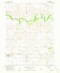
1960 Map of Ruskin
USGS Topo · Published 1962About this map
The Little Blue River winds through the northern portion of this South Central Nebraska landscape, marking a distinct riparian corridor between the townships of Elk and Kiowa. The village of Ruskin serves as the primary settlement, situated in the southwest corner along the Chicago Rock Island and Pacific railroad line. This 1960 field-checked survey provides a clear view of the rural infrastructure at mid-century, characterized by a grid of section lines and a significant number of localized landmarks important for genealogical research.
Find a feature on this map
16 named features on this map. Tap any name to fly to it.
Don’t see what you’re looking for? This feature index may not catch every label — zoom into the map to look around manually.
Map Details
Editions of this 1960 Ruskin Map
This is the sole edition of this map. No revisions or reprints were ever made.
Other maps of this area

1898 · Hebron
USGS Topo · 1:125,000

1955 · Lincoln
USGS Topo · 1:250,000

1957 · Lincoln
USGS Topo · 1:250,000

1958 · Lincoln
USGS Topo · 1:250,000

1960 · Byron
USGS Topo · 1:24,000

1960 · Edgar
USGS Topo · 1:24,000

1960 · Davenport
USGS Topo · 1:24,000
1960 · Oak
USGS Topo · 1:24,000

1960 · Carleton
USGS Topo · 1:24,000
1960 · Hebron SW
USGS Topo · 1:24,000