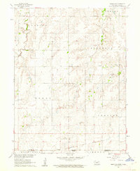
1960 Map of Hebron SW
USGS Topo · Published 1962About this map
The Nebraska-Kansas state line bisects this agricultural landscape, where the rural sections of Thayer County meet Republic County. The terrain is defined by the drainage patterns of Spring Creek and Dry Creek, which cut through the undulating plains between established townships like Byron and Chester. This 1960 field-checked survey highlights the systematic organization of the American heartland, marked by the regular intervals of section lines and the persistence of local institutions.
Find a feature on this map
14 named features on this map. Tap any name to fly to it.
Don’t see what you’re looking for? This feature index may not catch every label — zoom into the map to look around manually.
Map Details
Editions of this 1960 Hebron SW Map
This is the sole edition of this map. No revisions or reprints were ever made.
Other maps of this area

1892 · Concordia
USGS Topo · 1:125,000

1898 · Hebron
USGS Topo · 1:125,000

1955 · Manhattan
USGS Topo · 1:250,000

1955 · Lincoln
USGS Topo · 1:250,000

1956 · Manhattan
USGS Topo · 1:250,000

1957 · Manhattan
USGS Topo · 1:250,000

1957 · Lincoln
USGS Topo · 1:250,000

1958 · Lincoln
USGS Topo · 1:250,000

1960 · Byron
USGS Topo · 1:24,000

1960 · Chester
USGS Topo · 1:24,000