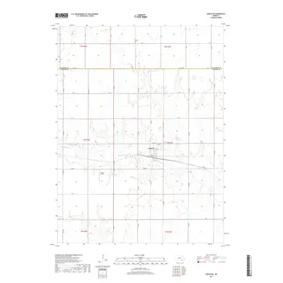
2017 Map of Carleton
USGS Topo · Published 2017About this map
Carleton serves as the central hub of this agricultural landscape in southeastern Nebraska, situated where the grid of rural roads meets the winding path of Big Sandy Cr. The town's small street grid, including 1st St and 10th St, provides a focal point within a vast expanse of section lines and township boundaries. The map documents the rural infrastructure of the early 21st century, from the Folkerts Airport to the Weddell Reservoir, reflecting the modern balance of aviation, water management, and tradition. To the north, the Summit Cem stands as a point of interest for genealogists, located near the border of Fillmore Co and Thayer Co. This survey illustrates the persistent importance of the section-line road network, such as Rd X and Rd W, in organizing the region's agricultural life.
Find a feature on this map
25 named features on this map. Tap any name to fly to it.
Don’t see what you’re looking for? This feature index may not catch every label — zoom into the map to look around manually.
Map Details
Editions of this 2017 Carleton Map
This is the sole edition of this map. No revisions or reprints were ever made.
Other maps of this area

1898 · Hebron
USGS Topo · 1:125,000

1955 · Lincoln
USGS Topo · 1:250,000

1957 · Lincoln
USGS Topo · 1:250,000

1958 · Lincoln
USGS Topo · 1:250,000

1960 · Bruning
USGS Topo · 1:24,000

1960 · Davenport
USGS Topo · 1:24,000

1960 · Carleton
USGS Topo · 1:24,000
1960 · Ruskin
USGS Topo · 1:24,000
1960 · Hebron
USGS Topo · 1:24,000
1960 · Deshler
USGS Topo · 1:24,000