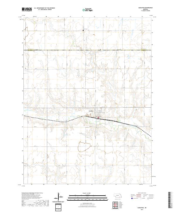
2021 Map of Carleton
USGS Topo · Published 2021About this map
Carleton serves as the central hub of this agricultural landscape in southern Nebraska, situated along the undulating valley of Big Sandy Cr. The village is meticulously organized with a grid of streets including E St, C St, and 10th St, indicating a structured community layout preserved since its early development. To the north, Summit Cem rests on higher ground near Co Line Rd, which marks the boundary between Fillmore and Thayer counties.
Find a feature on this map
40 named features on this map. Tap any name to fly to it.
Don’t see what you’re looking for? This feature index may not catch every label — zoom into the map to look around manually.
Map Details
Editions of this 2021 Carleton Map
This is the sole edition of this map. No revisions or reprints were ever made.
Other maps of this area

1898 · Hebron
USGS Topo · 1:125,000

1955 · Lincoln
USGS Topo · 1:250,000

1957 · Lincoln
USGS Topo · 1:250,000

1958 · Lincoln
USGS Topo · 1:250,000

1960 · Bruning
USGS Topo · 1:24,000

1960 · Davenport
USGS Topo · 1:24,000

1960 · Carleton
USGS Topo · 1:24,000
1960 · Ruskin
USGS Topo · 1:24,000
1960 · Hebron
USGS Topo · 1:24,000
1960 · Deshler
USGS Topo · 1:24,000