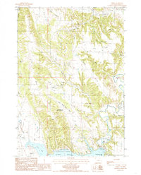
1984 Map of Carlile
USGS Topo · Published 1985About this map
The settlement of Carlile serves as a focal point in this 1984 Wyoming survey, where the drainages of Cabin Creek and Thorn Creek meet among the high divides of Crook County. The landscape reflects a diverse economic history, from the extractive operations at an Uranium Mine and Bentonite Pits to the agricultural and spiritual centers like Pine Ridge Ch. To the south, the massive footprint of the Keyhole Reservoir dominates the terrain, held by the Keyhole Dam near the Belle Fourche River. This area, protected as Keyhole State Park, shows the developed recreational shoreline at Cottonwood Creek Bay and Deer Creek Bay. Notable geologic landmarks are also documented, including the Monumental City (Rock Formation) in Eggie Basin, and the prominent Pine Ridge which separates the northern draws from the river valley.
Find a feature on this map
46 named features on this map. Tap any name to fly to it.
Don’t see what you’re looking for? This feature index may not catch every label — zoom into the map to look around manually.
Map Details
Editions of this 1984 Carlile Map
This is the sole edition of this map. No revisions or reprints were ever made.
Other maps of this area

1905 · Devils Tower
USGS Topo · 1:125,000

1918 · Moorcroft
USGS Topo · 1:125,000

1918 · Moorcroft
USGS Topo · 1:62,500

1954 · Sunny Divide
USGS Topo · 1:24,000

1954 · Carlile
USGS Topo · 1:24,000

1954 · Missouri Buttes
USGS Topo · 1:24,000

1954 · Gillette
USGS Topo · 1:250,000

1955 · Devils Tower
USGS Topo · 1:62,500

1955 · Gillette
USGS Topo · 1:250,000

1957 · Nefsy Divide
USGS Topo · 1:62,500