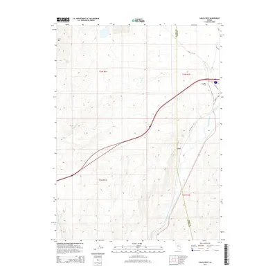
2014 Map of Carlin West
USGS Topo · Published 2014About this map
The Humboldt River corridor dominates the eastern landscape of this Nevada survey, serving as the primary artery for both water and infrastructure. The western edge of Carlin is visible where Interstate 80 and the railroad corridors converge near the river's bend. This area transitions from the river valley floor toward the high terrain of Marys Mtn in the northwest, showing a classic Great Basin pattern of settlement clinging to the accessible valley routes while the upland reaches remain defined by isolated water sources like Cherry Spring.
Find a feature on this map
18 named features on this map. Tap any name to fly to it.
Don’t see what you’re looking for? This feature index may not catch every label — zoom into the map to look around manually.
Map Details
Editions of this 2014 Carlin West Map
This is the sole edition of this map. No revisions or reprints were ever made.
Other maps of this area

1952 · Carlin
USGS Topo · 1:62,500

1955 · Winnemucca
USGS Topo · 1:250,000

1957 · Beowawe
USGS Topo · 1:62,500

1958 · Winnemucca
USGS Topo · 1:250,000

1958 · Huntsman Ranch
USGS Topo · 1:24,000

1962 · Winnemucca
USGS Topo · 1:250,000

1968 · Welches Canyon
USGS Topo · 1:24,000
1968 · Schroeder Mtn
USGS Topo · 1:24,000
1975 · Carlin NE
USGS Topo · 1:24,000

1985 · Scotts Gulch
USGS Topo · 1:24,000