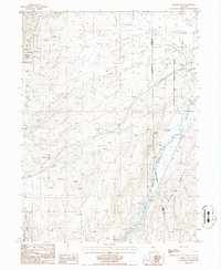
1985 Map of Carlin West
USGS Topo · Published 1986About this map
Marys Mountain and the southern reaches of the Pinon Range dominate this Nevada landscape during the mid-1980s. The topography is defined by the winding course of the Humboldt River, which cuts through the eastern portion of the map, creating a fertile corridor for the settlement at Tyrol. Water remains a central theme in this high-desert environment, evidenced by numerous named springs such as Warm Spring and Cherry Spr, alongside various stock tanks and flumes.
Find a feature on this map
24 named features on this map. Tap any name to fly to it.
Don’t see what you’re looking for? This feature index may not catch every label — zoom into the map to look around manually.
Map Details
Editions of this 1985 Carlin West Map
This is the sole edition of this map. No revisions or reprints were ever made.
Other maps of this area

1952 · Carlin
USGS Topo · 1:62,500

1955 · Winnemucca
USGS Topo · 1:250,000

1957 · Beowawe
USGS Topo · 1:62,500

1958 · Winnemucca
USGS Topo · 1:250,000

1958 · Huntsman Ranch
USGS Topo · 1:24,000

1962 · Winnemucca
USGS Topo · 1:250,000

1968 · Welches Canyon
USGS Topo · 1:24,000
1968 · Schroeder Mtn
USGS Topo · 1:24,000
1975 · Carlin NE
USGS Topo · 1:24,000

1985 · Scotts Gulch
USGS Topo · 1:24,000