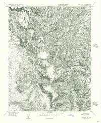
1955 Map of Carlisle 3 SE
USGS Topo · Published 1956About this map
Chesler Park and the striking geological forms of The Needles dominate this mid-century topographic record of San Juan County. Based on 1953 aerial photography, the map reveals a landscape defined by complex erosion and deep drainage systems, notably the winding path of Butler Wash and the headwaters of Salt Creek. The survey captures the area in a raw, transitional mapping phase as a preliminary edition, showing the intricate contour work required to document the high-desert plateaus and basins before later development or formal designations. In the southwestern corner, Beef Basin appears as a distinct topographic depression, while various unnamed branches of Creek and Fork illustrate the labyrinthine network of seasonal waterways that shaped the local travel routes and grazing potential of the era.
Find a feature on this map
7 named features on this map. Tap any name to fly to it.
Don’t see what you’re looking for? This feature index may not catch every label — zoom into the map to look around manually.
Map Details
Editions of this 1955 Carlisle 3 SE Map
This is the sole edition of this map. No revisions or reprints were ever made.
Other maps of this area

1885 · La Sal
USGS Topo · 1:250,000

1886 · Abajo
USGS Topo · 1:250,000

1892 · Abajo
USGS Topo · 1:250,000

1893 · Abajo
USGS Topo · 1:250,000

1935 · Elk Ridge
USGS Topo · 1:96,000

1940 · Elk Ridge
USGS Topo · 1:125,000

1953 · Carlisle 3 NW
USGS Topo · 1:24,000

1953 · The Needles
USGS Topo · 1:62,500

1954 · Elk Ridge 1 NW
USGS Topo · 1:24,000

1954 · Carlisle 4 SW
USGS Topo · 1:24,000