
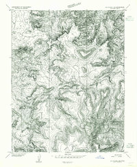
1954 Map of Carlisle 4 SW
USGS Topo · Published 1954About this map
Cliff Dwellings tucked into the complex drainage systems of Salt Creek define this 1954 preliminary survey of San Juan County. The landscape is a labyrinth of erosion, characterized by the high elevations of Cedar Mesa and Bridger Jack Mesa, which tower over deeply incised watercourses like Horse Canyon. This map was produced during a transition in cartographic methods, utilizing multiplex photogrammetry from 1953 aerial photography to document a terrain where modern development was nearly non-existent. Aside from a single Prospect in the northeast and the ancient archaeological sites, the area remains dominated by its natural geometry. The inclusion of Big Pocket and various unnamed forks illustrates the remote character of the territory before more detailed 15-minute series maps were finalized for the region.
Find a feature on this map
11 named features on this map. Tap any name to fly to it.
Don’t see what you’re looking for? This feature index may not catch every label — zoom into the map to look around manually.
Map Details
Editions of this 1954 Carlisle 4 SW Map
This is the sole edition of this map. No revisions or reprints were ever made.
Other maps of this area

1885 · La Sal
USGS Topo · 1:250,000

1886 · Abajo
USGS Topo · 1:250,000

1892 · Abajo
USGS Topo · 1:250,000

1893 · Abajo
USGS Topo · 1:250,000

1935 · Elk Ridge
USGS Topo · 1:96,000

1940 · Elk Ridge
USGS Topo · 1:125,000

1953 · The Needles
USGS Topo · 1:62,500

1954 · Elk Ridge 1 NW
USGS Topo · 1:24,000

1954 · Elk Ridge 1 NE
USGS Topo · 1:24,000
1954 · Elk Ridge 2 NE
USGS Topo · 1:24,000