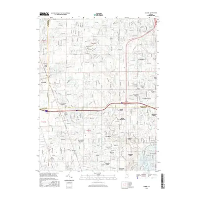
2016 Map of Carmel
USGS Topo · Published 2016About this map
The White River winds through the southeastern corner of this suburban landscape, anchoring a region defined by the meeting of Hamilton, Marion, and Boone counties. This area showcases the established communities of Carmel and Zionsville, interspersed with a dense network of residential additions and neighborhood names such as Home Place, Nora, and Meridian Hills. The map provides a detailed view of the transition from older settlements like Augusta and New Augusta to modern educational landmarks like The Art Institute of Indianapolis. Numerous local waterways, including Little Eagle Creek and Williams Creek, weave through the terrain, while historical sites like Poplar Ridge Cem and Carmel Cem offer points of interest for those researching local genealogy. The layout reflects the rapid residential expansion north of Indianapolis, where traditional township grids meet newer winding suburban developments.
Find a feature on this map
109 named features on this map. Tap any name to fly to it.
Don’t see what you’re looking for? This feature index may not catch every label — zoom into the map to look around manually.
Map Details
Editions of this 2016 Carmel Map
This is the sole edition of this map. No revisions or reprints were ever made.
Other maps of this area

1948 · Indianapolis East
USGS Topo · 1:24,000

1948 · Indianapolis West
USGS Topo · 1:24,000

1952 · Fishers
USGS Topo · 1:24,000

1952 · Carmel
USGS Topo · 1:24,000

1953 · Westfield
USGS Topo · 1:24,000

1953 · Rosston
USGS Topo · 1:24,000

1953 · Zionsville
USGS Topo · 1:24,000

1953 · Noblesville
USGS Topo · 1:24,000

1953 · Clermont
USGS Topo · 1:24,000

1953 · Danville
USGS Topo · 1:250,000