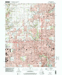
1998 Map of Carmel
USGS Topo · Published 2002About this map
Suburban expansion across northern Indianapolis and southern Carmel is captured here during the late 1990s, revealing a landscape transitioning from rural townships to established residential developments. The area between Zionsville and Carmel shows a dense network of numbered streets and residential pockets like Sherwood Forest and College Meadows. Significant educational and religious institutions are distributed throughout the terrain, including Our Lady of Mt Carmel Sch and the State Sch for the Blind near the White River.
Find a feature on this map
86 named features on this map. Tap any name to fly to it.
Don’t see what you’re looking for? This feature index may not catch every label — zoom into the map to look around manually.
Map Details
Editions of this 1998 Carmel Map
This is the sole edition of this map. No revisions or reprints were ever made.
Other maps of this area

1948 · Indianapolis East
USGS Topo · 1:24,000

1948 · Indianapolis West
USGS Topo · 1:24,000

1952 · Fishers
USGS Topo · 1:24,000

1952 · Carmel
USGS Topo · 1:24,000

1953 · Westfield
USGS Topo · 1:24,000

1953 · Rosston
USGS Topo · 1:24,000

1953 · Zionsville
USGS Topo · 1:24,000

1953 · Noblesville
USGS Topo · 1:24,000

1953 · Clermont
USGS Topo · 1:24,000

1953 · Danville
USGS Topo · 1:250,000